· Castles & Palaces · 4 min read ·
Walled Town of Vidoški: The Fortress That Guarded Herzegovina
Perched above the Bregava River, the medieval citadel of Vidoški survived Ottoman sieges and Austro-Hungarian artillery overhauls in southern Herzegovina.
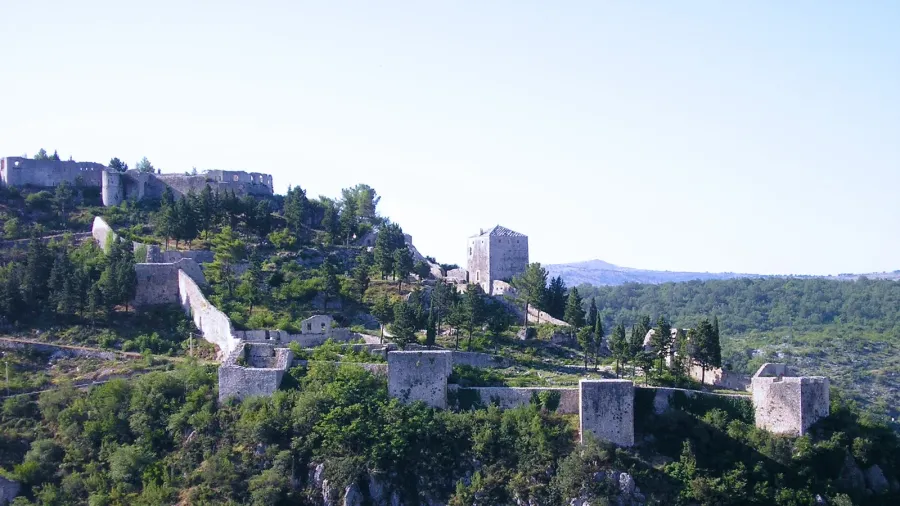
Rising above the modern town of Stolac in southern Bosnia and Herzegovina, the walled town of Vidoški occupies a prominent limestone ridge over the Bregava River valley. Covering more than 20,000 square meters, this defensive complex represents one of the largest fortified strongholds in the western Balkans. Its architectural fabric preserves distinct construction phases spanning over five centuries, recording the territorial struggles between medieval Bosnian lords, the Ottoman Empire, and the Austro-Hungarian military administration.
 Figure 1: Relief map showing the strategic placement of Stolac in southern Bosnia and Herzegovina.
Strategic geography along the Bregava
The citadel occupies the Križevac hill, an elevation that commands natural trade routes connecting the Adriatic coast with the Balkan interior. In antiquity, the fertile valley below was known as Vidovo Polje, home to late Roman settlements and the sixth-century bishopric of Sarsenterum. Medieval records first document the settlement below the fortress in 1420 under the name Stolac, while the fortress itself appears in historical charters in February 1444 during the reign of Duke Stjepan Vukčić Kosača.
During the fifteenth century, the fortress guarded the eastern perimeter of Kosača’s domain against territorial expansion by rival regional rulers. The fortress takes its name from the river Vidoštica, the medieval designation for the Bregava, as well as the regional cult of Saint Vid. Positioned on jagged limestone cliffs, the fortifications controlled caravan traffic carrying salt, textiles, and metals between Dubrovnik and continental commercial outposts.
 Figure 2: Map of Herzegovina-Neretva Canton where the fortress dominates the Bregava river valley.
Three fortification tiers and structural anatomy
Architecturally, the stronghold divides into three interconnected enclosures: the lower town, the middle town, and the upper town. Built from local grey limestone blocks, the defensive perimeter measures roughly two meters in wall thickness and originally incorporated thirteen defensive towers. This layout gave Vidoški the reputation of being the most formidable fortress in seventeenth-century Herzegovina.
The lower town covers 8,481 square meters along the northwestern slope. Its fortified perimeter features a vaulted gatehouse on the northeastern wall with dedicated guard chambers. Within this section stand the ruins of the Veli-Deda mosque, constructed during Ottoman rule with an octagonal minaret base, along with a subterranean water cistern. Heavy curtain walls pierced with two distinct tiers of musketry loopholes link the northern towers, allowing overlapping fields of fire across the hillside approach.
The upper town crowns the highest plateau of the ridge, covering 8,579 square meters. Five specialized defensive towers guard this section. The easternmost tower served as an ammunition magazine, surviving multiple lightning strikes and defensive sieges. Rainwater collection systems proved critical for prolonged survival; ten separate stone cisterns across the complex stored mountain runoff to sustain garrisons during dry summer months and enemy blockades.
 Figure 3: Carved medieval stećak tombstones near Stolac dating from the era of the Bosnian kingdom.
Ottoman expansion and Austro-Hungarian transformation
Ottoman forces under Sultan Mehmed II captured Vidoški between 1465 and 1469, incorporating it into the Sanjak of Herzegovina. In 1706, Ottoman authorities established the military Captaincy of Stolac, turning the fortress into a primary administrative center. Venetian forces attempted to capture the citadel during the Ottoman-Venetian War of 1714 to 1718, but the defensive garrison repelled all assaults. By the early nineteenth century, local leader Ali-paša Rizvanbegović governed the region from this stronghold, further reinforcing the perimeter walls.
The final major construction phase occurred following Austro-Hungarian occupation in 1878. Habsburg military engineers surveyed the medieval and Ottoman ruins, adapting them to modern artillery warfare. Between 1888 and 1889, the imperial army erected the modern fortress known as Werk Stari Grad. They installed two pentagonal artillery platforms equipped with 90-millimeter guns, built semi-circular stone caponiers for flanking rifle fire, and introduced telegraph and water systems. Today, the Commission to Preserve National Monuments protects the citadel as an official national monument of Bosnia and Herzegovina.