· Cities & Capitals · 4 min read ·
Wuhan: China's Inland Thoroughfare and Tri-City Hub
Divided by rivers into three historic towns, Wuhan anchors central China as a strategic confluence of commerce, industry, and watershed history.
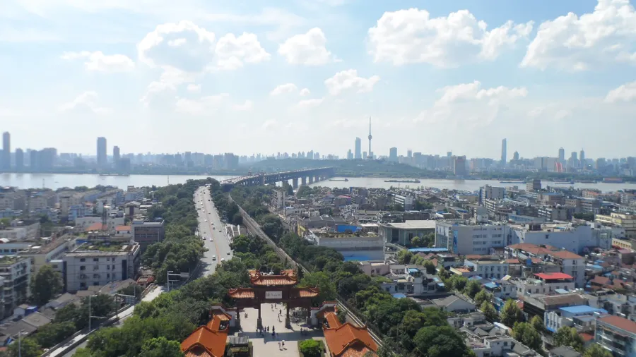
Wuhan stands at the confluence of the Yangtze River and its primary tributary, the Han River, occupying the eastern edge of the Jianghan Plain. As the capital of Hubei province, the city houses 13.86 million residents, making it the most populous urban center in central China and the seventh most populous nationally. The contemporary metropolis formed through the amalgamation of three historically separate settlements: Wuchang on the southern bank of the Yangtze, Hankou on the northern bank between the two rivers, and Hanyang south of the Han. Together known as the Three Towns of Wuhan, their geographic position established the area early on as the Thoroughfare of Nine Provinces.
The three towns at the river confluence
Water defined the boundary lines and development of each district. Hankou grew into a mercantile port handling regional commerce, while Wuchang developed as an administrative and cultural seat, and Hanyang fostered early industrial foundries. In 1957, the opening of the Wuhan Yangtze River Bridge spanned the waterway, connecting the northern and southern rail networks for the first time. The river system continues to function as a freight corridor, termed China’s Golden Waterway, carrying domestic and international cargo deep into the continental interior.
 Figure 1: Map of Wuhan’s administrative divisions, showing the three historical towns of Wuchang, Hankou, and Hanyang.
Crucible of twentieth-century revolutions
The city served as the starting point for modern China’s political transformation. On October 10, 1911, the Wuchang Uprising erupted among military units stationed in the city, triggering the Xinhai Revolution that overthrew the Qing dynasty and dissolved two millennia of imperial monarchy. Wuhan later served as the national seat of government on two separate occasions during the early twentieth century. A left-wing Kuomintang administration governed from the city in 1927, and Wuhan operated as China’s wartime capital in 1937 following the fall of Nanjing. During the four-month Battle of Wuhan in 1938, Chinese forces fought Japanese advances across the river basin, delaying the offensive before withdrawing further inland.
Because of its intersection of trunk rail lines, highway networks, and navigable waterways, observers in the early twentieth century frequently referred to Wuhan as the Chicago of China. Hankou Railway Station, completed in the early 1900s as the southern terminus of the Jinghan Railway, handled passenger traffic and commodity trade moving between northern industrial basins and southern ports. Today, Wuhan remains one of nine designated national central cities, directing transit flows between Beijing, Guangzhou, Shanghai, and Chengdu.
 Figure 2: Historic postcard depicting Hankow Railway Station in 1927, capturing its central role in regional transit.
Inland water engineering and urban growth
Proximity to major river systems brought recurring seasonal flood hazards. Severe inundations prompted city authorities to rebuild dikes and later implement urban water management initiatives, turning municipal districts into permeable spaces designed to absorb and filter excess runoff. Further upstream, the construction of the Three Gorges Dam on the Yangtze provided hydraulic control mechanisms that reduced seasonal peak flows through the Jianghan Plain.
Modern Wuhan has transitioned from heavy metallurgy into high-technology manufacturing and advanced scientific research. In 2025, the municipality recorded a nominal gross domestic product of 318 billion dollars. The city serves as corporate headquarters for Dongfeng Motor Corporation and hosts operations for 230 Fortune Global 500 corporations across three national development zones and four technology parks. Over 350 research institutes and 1,600 high-technology enterprises operate in the metropolitan area.
Scientific research and contemporary standing
Higher education anchors the city’s technical workforce. Institutions such as Wuhan University and Huazhong University of Science and Technology contribute to Wuhan’s academic output, placing the city eighth globally and fifth in the Asia-Pacific region for scientific research volume. In 2017, UNESCO recognized the city as a Creative City of Design, and the Globalization and World Cities Research Network classifies Wuhan as a Beta tier global city.
Beyond research and manufacturing, Wuhan functions as a leading financial nexus in the interior. Classified among the world’s top one hundred financial centers according to the Global Financial Centres Index, the city coordinates monetary flows and capital allocation across the middle Yangtze basin. Anchored by centuries of riverine trade and extensive high-speed overland networks, the three historic towns maintain their collective stature as the central economic fulcrum of inland China.