· World Landmarks · 4 min read ·
Sugar Loaf: The Glacial Monolith Stranded on Mackinac Island
Standing 75 feet above the hardwood forest of Mackinac Island, Sugar Loaf is an ancient limestone sea stack stranded inland when glacial meltwaters drained.
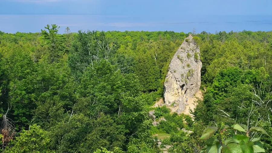
In the dense hardwood forest of central Mackinac Island, a solitary rock tower rises seventy-five feet above the ground. Known as Sugar Loaf, this conical pillar stands hundreds of yards from the modern shoreline of Lake Huron. To an observer walking along Crooked Tree Road, the formation appears out of place amid the trees. Geologists recognize it as an ancient sea stack, a coastal rock formation carved by relentless waves and left behind when ancestral lakes receded thousands of years ago.
The origin of Sugar Loaf dates back roughly eleven thousand years to the end of the Wisconsin glaciation. As the Laurentide Ice Sheet retreated northward across the Great Lakes basin, meltwater filled the depression to form glacial Lake Algonquin. This vast body of water had a surface elevation substantially higher than modern Lake Huron. Lake Algonquin submerged nearly the entire landmass that forms present-day Mackinac Island. Only the highest central plateau, often termed the Ancient Island or Turtle’s Back, projected above the cold water.
Sub-arctic winds and polar storms swept across Lake Algonquin, generating heavy wave action across the open water. These waves attacked the cliffs of the Ancient Island. Most of the island consists of Mackinac breccia, a sedimentary formation composed of angular limestone and dolomite fragments cemented together during the Devonian period. While wave friction wore away the surrounding weaker stone, an exceptionally hard, well-cemented core of breccia resisted the constant pounding of the surf. Over centuries of hydraulic abrasion, water cut this resistant mass away from the main island mass.
 Figure 1: Relief map of Michigan displaying the Straits of Mackinac waterway connecting Lake Michigan and Lake Huron.
When the ice dams holding Lake Algonquin gave way, new drainage outlets opened toward the east through the Ottawa River valley. Lake levels dropped precipitously during the subsequent Lake Stanley low-water stage, before rebounding during the Nipissing transgression around four thousand years ago. As the water retreated to the current Great Lakes configuration, the shoreline withdrew hundreds of yards downhill. The wave-cut sea stack, once isolated by offshore currents, became permanently landlocked within an emerging temperate forest.
Long before European cartographers mapped the Straits of Mackinac, the indigenous Anishinaabe peoples, including the Ojibwe and Odawa, held the island sacred. In regional oral traditions, Mackinac Island served as a sacred gathering place, and Sugar Loaf occupied a prominent position in indigenous cosmology. Several accounts identified the imposing stone tower as the home or physical manifestation of Gitchi Manitou, the Great Spirit. Other oral narratives recounted that the rock was a person turned to stone as a punishment for disobedience. Visiting hunters left offerings of tobacco at its base to ensure safe passage across the treacherous straits.
 Figure 2: The 75-foot limestone breccia monolith of Sugar Loaf rises directly from the Mackinac Island interior floor.
During the nineteenth century, geologists such as Henry Schoolcraft and Alexander Winchell examined Sugar Loaf while surveying Michigan’s natural resources. Their field observations confirmed that the rock shared identical strata with nearby Arch Rock, proving that both features owed their existence to ancient high-water lake stages. When Mackinac National Park was established in 1875, later transitioning to Michigan’s first state park in 1895, authorities placed Sugar Loaf under statutory protection. Today, visitors view the stack from Point Lookout near Fort Holmes, where its crown remains visible above the forest canopy.
Sugar Loaf represents the largest post-glacial erosion feature preserved anywhere in the Straits of Mackinac. Its rough, conglomerate surface displays angular limestone blocks fused within a fine-grained carbonate matrix, demonstrating the mechanical processes that shaped North America’s post-glacial geography. The formation stands as a quiet record of rapid climatic change, showing how melting glaciers and ancient lake levels transformed the Great Lakes terrain.