· World Landmarks · 4 min read ·
Point of Beginning: The Submerged Marker That Shaped the American Grid
Submerged beneath the Ohio River lies the survey point that established the rectangular grid system, dividing millions of acres across the American continent.
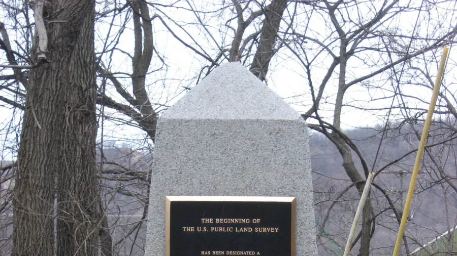
On the northern bank of the Ohio River, near the boundary where Ohio meets Pennsylvania, the physical starting point of the United States Public Land Survey rests beneath several feet of water. Modern industrial dams along the river raised the waterline in the twentieth century, hiding the original reference mark where surveyor Thomas Hutchins placed his instruments in September 1785. A granite obelisk now marks the boundary line on higher ground along the roadside between East Liverpool, Ohio, and Ohioville, Pennsylvania, documenting the geodetic origin of the American public domain.
Before 1785, European settlement in North America relied on the metes-and-bounds method of property division. Land deeds referenced variable markers such as oak trees, stone piles, river bends, and adjacent private claims. This approach caused overlapping boundaries, costly title litigation, and uncertain property lines in the original thirteen colonies. Seeking to pay off national Revolutionary War debts through orderly land sales, the Continental Congress passed the Land Ordinance of 1785. Drafted by a committee that included Thomas Jefferson, the legislation created a uniform cadastral framework that replaced descriptive boundaries with an absolute mathematical grid.
 Figure 1: The eastern face of the granite monument marks the state line in Ohioville, Pennsylvania, commemorating the 1785 survey.
Congress appointed Thomas Hutchins as Geographer of the United States to lead the field operations. His assignment was to establish the Point of Beginning on the western boundary of Pennsylvania, at the northern shore of the Ohio River. From that fixed coordinate, survey teams measured due west along a baseline known as the Geographer’s Line. Every six miles, teams ran perpendicular survey lines south to the river, forming the initial block known as the Seven Ranges. The grid organized land into square townships six miles on each side, further divided into thirty-six numbered sections of 640 acres each. Section 16 in every township was reserved by law to generate funds for public schools.
The technical execution required strict discipline under primitive conditions. Survey crews used Gunter’s chains, made of 100 iron links measuring precisely 66 feet, along with solar compasses and plumb bobs. Dense hardwood forests, steep ravines, and swampy bottomlands slowed daily progress. Axemen cleared sightlines through thick timber, while chainmen measured distances step by step, compensating for elevation changes on uneven hillsides. Hutchins began measurements in the autumn of 1785, but halted operations after only four miles due to indigenous resistance and hostile conditions. He returned the following summer with military escorts from Fort Harmar, completing the survey of the Seven Ranges in 1787.
 Figure 2: The National Historic Landmark bronze plaque installed near the highway to mark the historic cadastral boundary.
The Northwest Ordinance of 1787 expanded the rectangular survey method across the entire Northwest Territory. The grid system governed land distribution across lands that eventually became Ohio, Indiana, Illinois, Michigan, Wisconsin, and eastern Minnesota. This project was the first large-scale national cadastral survey based entirely on mathematical coordinates rather than physical landmarks. As settlers moved westward, the rectangular system extended across the Great Plains and the Pacific Northwest, ultimately organizing more than one billion acres of public land into predictable geometric parcels.
The original wooden post set by Hutchins disappeared beneath the waterline when navigation projects reshaped the Ohio River. Construction of the Montgomery Island Lock and Dam in the 1930s permanently flooded the low bank. In 1881, local authorities and state surveyors erected the present granite monument 1,112 feet north of the original submerged point to keep the historic line visible to the public. The site received National Historic Landmark status in 1965, recognized for its foundational influence on continental settlement. Viewed from commercial airplanes or orbital satellites, the checkerboard layout across the central United States, visible in county roads, agricultural fields, and municipal boundaries, directly traces its geometry to this riverbank coordinate.