· History & Civilization · 5 min read ·
How the Shifting Waters of Sidi El Hani Redraw Tunisia's Internal Borders
Across the arid plains southwest of Sousse, the endorheic basin of Sidi El Hani swells into a 370-square-kilometer sea that shifts provincial boundaries.
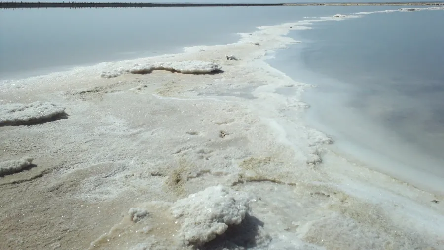
Heat shimmers across a blinding crust of white alkali, stretching toward a flat horizon where the low scrub of eastern Tunisia dissolves into mirage. For months at a time, the vast sunken floor of Sebkhet Sidi El Hani sits silent, locked beneath cracked geometric plates of dry mineral salts. Stand at its southern rim in mid-summer, and the landscape appears permanently desiccated. Yet when winter downpours sweep across the steppes of Kairouan, thousands of seasonal gullies suddenly reverse the desert silence. Water converges from every direction into this closed depression, transforming more than 370 square kilometers of sun-baked earth into one of North Africa’s largest and most volatile inland seas.
This sudden hydrologic surge creates an extraordinary administrative dilemma. Unlike permanent lakes bounded by fixed shorelines, Sebkhet Sidi El Hani expands and contracts with violent seasonality. At maximum inundation, its shallow brine spreads across the territorial boundaries of Sousse, Mahdia, and Monastir, drowning surveyor lines beneath forty centimeters of mineral-rich water. For the agrarian town of Sidi El Hani, perched just beyond the northwest shoreline, the fluctuating salt pan has dictated civil geometry, trade networks, and regional politics for centuries.
 Figure 1: Evaporite minerals and saline deposits tint the floor of Sebkhet Sidi El Hani during summer dry-down. Photo: Frejalaya (CC BY-SA 4.0).
The Mechanics of a Terminal Basin
Geologically, Sebkhet Sidi El Hani represents the terminal floor of a massive endorheic drainage network that also encompasses the smaller playas of Chrita and Mechertat. The depression forms an eastward-facing structural basin carved between the coastal Sahel uplands and the eastern margins of the Kairouan plain. With no natural outlet to the Mediterranean Sea, located roughly thirty kilometers to the east, any rain falling across its 1,100-square-kilometer catchment area has only two possible exits: underground infiltration or solar evaporation.
Because the local water table sits close to the surface, groundwater continuously seeps upward through the fine-grained silts and clays of the playa. Capillary action draws mineralized brine to the surface, where blistering summer temperatures exceeding forty degrees Celsius trigger intense evaporation. As water molecules vaporize into the dry Sahel air, they leave behind dense crusts of halite, gypsum, and alkaline carbonates. The result is a geological engine operating on chaotic feedback loops: seasonal rainfall dilutes the playa, groundwater pressure stabilizes the fluid column, and summer heat recrystallizes the surface into a brilliant white expanse.
 Figure 2: Geometric desiccation cracks and salt ridges across the dry playa bed of the basin. Photo: Frejalaya (CC BY-SA 4.0).
A Liquid Border on the Tunisian Steppe
The practical consequence of this hydrological cycle is a border that refuses to stay put. Official administrative cartography in Tunisia places the primary body of the lake inside Sousse Governorate. However, during severe flood cycles, the southeastern fingers of the inundation breach low thresholds, merging into neighboring pastures and marshlands. The easternmost extent of the flood line serves as the legal demarcation line with Monastir Governorate, meaning that the formal contact zone between administrative jurisdictions is literally defined by rainfall decibels recorded hundreds of kilometers away in the interior Dorsal mountains.
Human infrastructure has had to adapt to this shifting terrain. The modern town of Sidi El Hani sits nineteen kilometers east of Kairouan and twenty-six kilometers from the historic Aghlabid capital of Raqqada. Rather than skirting the treacherous mud flats by long detours, early surveyors routed the regional rail corridor of Tunisian Railways along the stable limestone rises northwest of the depression. Parallel to the tracks runs the P12 highway, connecting the industrial port of Sousse with Kairouan. Travelers along this corridor witness a dramatic transition from dense olive groves to absolute planetary emptiness in the span of a single kilometer.
 Figure 3: Aerial perspective of Sebkhet Sidi El Hani illustrating the vast expanse of the terminal drainage basin. Photo: Mohatatou (CC BY-SA 4.0).
Industrial Extraction and Avian Sanctuary
Despite its harsh salinity, the basin is far from barren. Along the southeastern perimeter, commercial salt works exploit the naturally replenished brine. Industrial evaporative pans extract over 200,000 tons of high-grade alkaline salt each year, driven by joint ventures that supply European chemical and food processing industries. Heavy transport tracks carve temporary roads directly into the dried playa floor during summer, hauling crystallized minerals from areas that will be navigable only by wading birds six months later.
When winter floods return, the industrial zone cedes territory to one of the central Mediterranean’s most vital avian refuges. Tens of thousands of migratory waterbirds descending along the Eurasian-African flyway touch down on the shallow sheet of water. Flocks of greater flamingos (Phoenicopterus roseus) gather across the submerged flats, sifting through the hyper-saline mud for brine shrimp and algae. As the water evaporates toward spring, the concentration of micro-organisms spikes, producing spectacular swirls of pink, ochre, and turquoise visible even from low Earth orbit.
 Figure 4: Industrial salt harvesting grounds operating within the southeastern depression. Photo: Frejalaya (CC BY-SA 4.0).
A Fragile Equilibrium Under Climate Pressure
Today, this delicate rhythm faces mounting environmental stresses. Intensifying droughts across the Maghreb have shortened the winter flood duration, while expanded groundwater pumping for inland olive cultivation threatens the underlying aquifers that feed the playa. When the water table drops, the capillary wick that maintains the crust weakens, allowing desertification to creep inward toward cultivated soil.
Sebkhet Sidi El Hani remains an enduring lesson in geographic impermanence. It is a territory that defies standard mapping conventions: simultaneously a lake and a desert, an industrial chemical quarry and a wild wetland, a barrier to transit and an international border defined entirely by the sky.