· Borders & Frontiers · 8 min read ·
Line of Control: The World's Most Militarized Ceasefire Frontier
Carving through Himalayan ridges, the Line of Control divides Kashmir under armed watch, frozen in geopolitical dispute since the 1972 Simla Agreement.
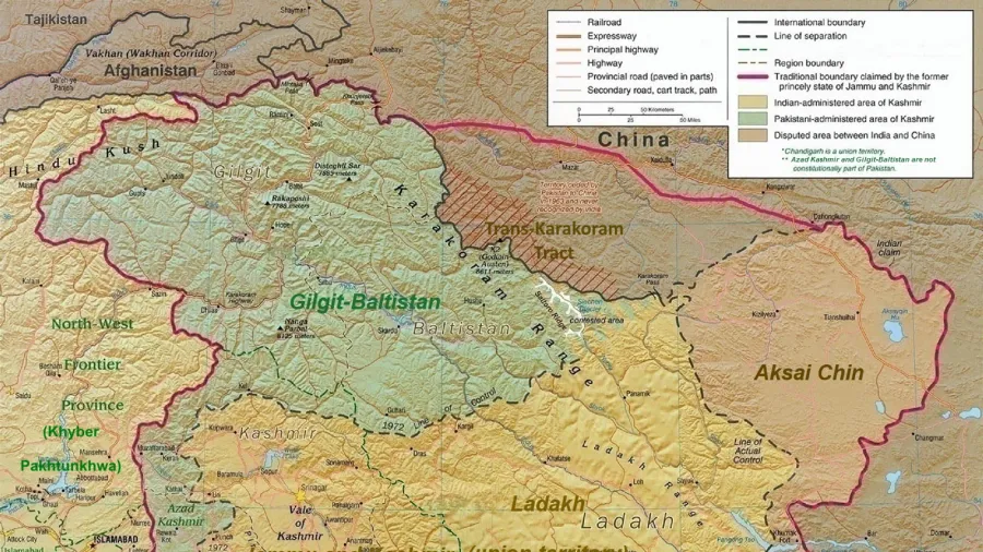
The Line of Control runs for more than 740 kilometers across the mountainous terrain of Jammu and Kashmir. It is not an internationally recognized legal boundary, but a military demarcation line that separates territories administered by India from those administered by Pakistan. Born out of two major regional wars and dozens of diplomatic accords, this boundary represents one of the most heavily fortified, actively contested, and strategically volatile frontiers anywhere on the globe.
Along its entire course, the line traverses extreme geographic elevations. It begins in the southern lowlands along the Chenab River near Akhnoor, climbs through dense subtropical pine forests in the Pir Panjal range, and ascends into the barren, glaciated heights of the Great Himalayas around Kargil, Dras, and the Saltoro Ridge. On both sides, hundreds of thousands of soldiers man elevated forward posts, concrete bunkers, and artillery observation points situated at altitudes exceeding 4,000 meters above sea level.
 Figure 1: Cartographic survey illustrating the alignment of the Line of Control across the Himalayan terrain of Kashmir.
Origins of the military demarcation
The division of Kashmir began with the partition of British India in August 1947. Under the terms of the Indian Independence Act, the hereditary ruler of the princely state of Jammu and Kashmir, Maharaja Hari Singh, had the choice to accede to either India or Pakistan or remain independent. In October 1947, armed Pashtun tribal militias backed by Pakistani forces advanced into the Kashmir Valley toward Srinagar. Confronted with a rapid military collapse, Hari Singh signed the Instrument of Accession to the Dominion of India on October 26, 1947, prompting the immediate deployment of Indian troops by air.
Fourteen months of conventional warfare followed across the valleys, mountain passes, and snowy plateaus of Kashmir. By late 1948, the conflict reached an operational stalemate. The United Nations Commission for India and Pakistan brokered an armistice that halted active hostilities on January 1, 1949. Later that year, military representatives from both governments met in Karachi to delineate a precise, surveyed line on maps.
Signed on July 27, 1949, the Karachi Agreement established the formal Ceasefire Line. United Nations military observers, organized under the United Nations Military Observer Group in India and Pakistan, deployed along the line to monitor compliance and investigate reported violations. The line divided the historic principality: India held the Kashmir Valley, Jammu, and Ladakh, while Pakistan administered the territories that became Azad Kashmir and the Northern Areas, later renamed Gilgit-Baltistan.
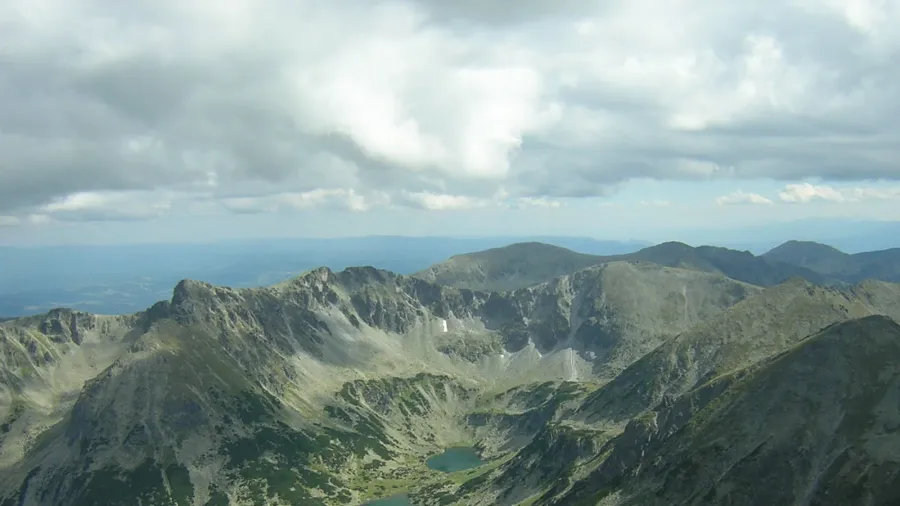
 Figure 2: The fortified mountain ridgeline and fencing viewed from the western slopes in Azad Kashmir.
The Simla transformation of 1972
The Ceasefire Line stood through the Indo-Pakistani War of 1965 with only minor adjustments. The decisive shift occurred during the war of December 1971. While the main fighting centered on East Pakistan and led to the creation of Bangladesh, intense battles simultaneously broke out across the western front in Kashmir. Both sides captured strategic outposts and tactical mountain tops across the 1949 line.
Following Pakistan’s defeat, Indian Prime Minister Indira Gandhi and Pakistani President Zulfikar Ali Bhutto convened in the hill station of Simla in July 1972 to negotiate a formal peace framework. The resulting Simla Agreement transformed the 1949 Ceasefire Line into the Line of Control. Crucially, paragraph 4(ii) of the accord stated that neither side would seek to alter the line unilaterally, irrespective of mutual differences and legal interpretations, and both committed to resolve all disputes through direct bilateral talks rather than third-party mediation.
Between August and December 1972, senior military surveyors from both armies conducted extensive joint field surveys. They produced 19 detailed map sheets, precisely marking the agreed coordinates of the Line of Control from the Chenab River in the south to a remote coordinate in the high Karakoram mountains.
 Figure 3: Historical 1958 topographic survey sheet depicting the rugged Dras sector along the early ceasefire alignment.
The northern terminus and the glacier war
The geographic definition of the Line of Control contains a deliberate cartographic gap. Both the 1949 Karachi Agreement and the 1972 Simla Agreement delineated the frontier northward across valleys and mountain passes until reaching a specific map coordinate: grid point NJ9842, located on the Saltoro Ridge east of the Shyok River. From NJ9842, the original text stated vaguely that the boundary would run “thence north to the glaciers.”
Military mapmakers left the line undefined beyond NJ9842 because the terrain was considered completely uninhabitable. It consisted of the vast, sub-zero expanse of the Siachen Glacier, flanked by 7,000-meter peaks of the Karakoram Range. For more than a decade, neither army stationed permanent units on the glacier itself. However, during the late 1970s, Pakistan began granting climbing permits to foreign mountaineering expeditions in the region, establishing administrative footprints on maps.
Alarmed by Pakistani cartographic activities, the Indian Army launched Operation Meghdoot on April 13, 1984. Indian troops airlifted by helicopters occupied the commanding heights and passes of the Saltoro Ridge, including Sia La and Bilafond La, securing military control over the entire Siachen Glacier. Pakistan responded with counter-attacks, establishing bases immediately to the west. This confrontation created the Actual Ground Position Line, turning the glaciated terrain north of NJ9842 into the highest battlefield in human history.
Fortification, sensors, and the barrier fence
For decades, the Line of Control remained a porous, open mountain boundary marked only by wooden posts, stone cairns, and military observation posts. In the early 1990s, armed insurgent groups began crossing the rugged ridgelines into the Kashmir Valley, leading to frequent skirmishes and regular artillery duels between Indian and Pakistani army garrisons. In 1999, the infiltration of Pakistani paramilitary soldiers across the line in the high-altitude Dras and Kargil sectors triggered the Kargil War, requiring months of airstrikes and infantry assaults to restore previous positions.
To curb infiltration, the Indian Army initiated construction of a physical barrier along the line in 2003, completing the project in late 2004. Known formally as the Anti-Infiltration Obstacle System, the barrier consists of a double row of concertina wire and electrified fencing measuring approximately 2.4 to 3 meters in height. The fence does not run precisely along the geographic treaty line in every sector; instead, engineers constructed it along military crests and ridges 100 to 500 meters inside Indian-administered territory to maximize defensive sightlines and tactical coverage.
The physical barrier incorporates modern surveillance hardware, including underground acoustic sensors, motion detectors, thermal imaging cameras, and night-vision radars. Patrols monitor the wire day and night, supported by illuminated searchlights visible from high-altitude aircraft. Despite heavy winter snowpacks that frequently crush entire sections of wire along steep avalanche chutes, dedicated engineering units reconstruct damaged spans every spring.
 Figure 4: Mountain valleys and terraced settlements adjacent to the contested frontier zone.
River hydrology and border definitions
The geography of the Line of Control is inextricably tied to the river systems of the Indus Basin. Crucial tributaries, including the Jhelum and Neelum rivers, flow across the frontier from Indian-administered territory into Pakistan-administered territory. The management of these transboundary waters remains governed by the 1960 Indus Waters Treaty, negotiated under the auspices of the World Bank. Even during periods of severe military tension, the treaty has survived, although disputes over upstream infrastructure, such as the Kishenganga Hydroelectric Plant in Gurez, have required formal adjudication before the Permanent Court of Arbitration in The Hague.
Geographers and international legal scholars distinguish between three separate boundary regimes in the region. To the south of the Line of Control, stretching from Akhnoor to the Ravi River, lies the sector dividing Pakistani Punjab from Indian Jammu. Pakistan designates this 200-kilometer stretch as the Working Border because it borders a territory whose status remains disputed, while India considers it a settled International Border. Further to the east in the high plateau of Ladakh, Indian forces face the Chinese People’s Liberation Army across the Line of Actual Control, which was established following the Sino-Indian War of 1962.
Today, the Line of Control remains under the direct operational supervision of the Indian and Pakistani armies. While a renewed bilateral ceasefire agreement established in February 2021 brought a reduction in cross-border artillery shelling, villages situated within rifle range of the wire continue to navigate minefields, underground shelter construction, and military checkpoints. Over seven decades after partition, the line stands as a permanent fixture on the political map of South Asia.