· Street View & Routes · 5 min read ·
The 15,000-Foot Valley That Formed the Lowest Gateway in the Himalayas
At 15,290 feet, Korala is an extreme mountain notch—yet it remains the lowest drivable gateway between the Tibetan Plateau and the Indian subcontinent.
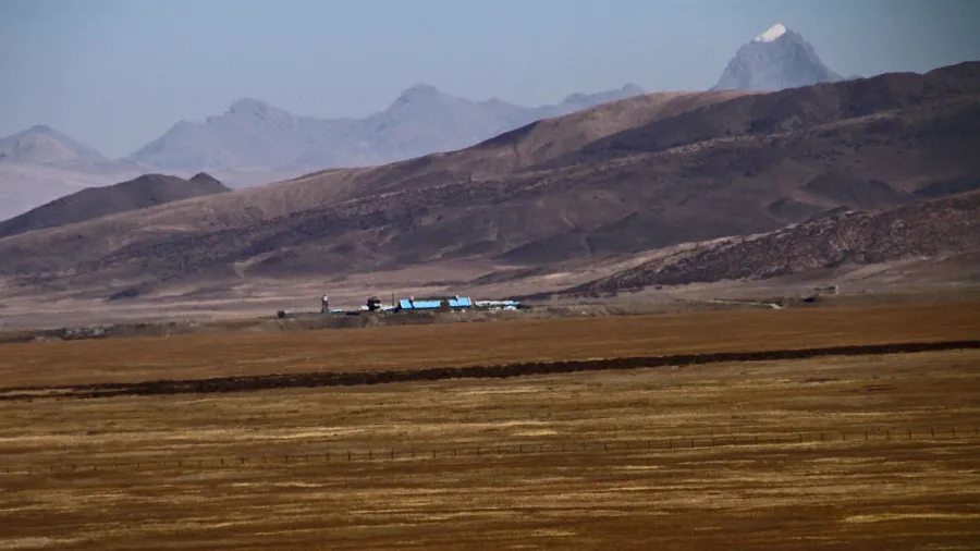
Gale-force winds scour the yellow gravel flats at 4,660 meters, where oxygen levels drop to barely half that of sea level. To the south, the jagged white ramparts of Dhaulagiri and Annapurna rear up past 8,000 meters, blocking the monsoon clouds and casting the high desert of Upper Mustang into perpetual rain shadow. Yet in this forbidding corner of the world, geography plays a counterintuitive trick. At nearly three miles above sea level, Korala is an extreme altitude environment, but in the context of the Himalayan barrier, it represents the single lowest drivable saddle between the Tibetan Plateau and the Indian subcontinent.
While modern commerce and geopolitical tension typically navigate passes like Nathu La or the rugged gorge at Kyirong, Korala remains the most structurally natural breach across the planet’s tallest mountain range. It sits squarely on the continental drainage divide. Rain falling a few hundred yards to the north drains into the Yarlung Tsangpo, which loops east before cutting south through the Brahmaputra into Bangladesh. Rain falling on the southern lip feeds the headwaters of the Kali Gandaki, which carves the deepest canyon on Earth on its direct descent toward the Ganges.
 Figure 1: Boundary fencing demarcating the frontier between Upper Mustang and Tibet across the windswept plain of Korala.
For over a thousand years, this broad gravel plain served as the economic jugular of the trans-Himalayan trade. Long before national borders were etched onto international treaties, caravans of shaggy yaks and mountain goats trod across Korala laden with rock salt harvested from the desiccated salt lakes of western Tibet. The salt was carried south through the ancient Kingdom of Lo, a feudal Buddhist realm culturally Tibetan yet politically semi-autonomous within the orbit of Nepal.
In the fortified mud-brick capital of Lo Manthang, just fifteen miles south of the pass, the Rajas of Mustang taxed the salt flow, exchanging the mineral for lowland grain, rice, and spice from the tropical valleys of the south. Because Korala lacks the sheer cliffs, icefalls, and avalanche gullies that plague eastern passes, pack animals could navigate the gentle plateau even in harsh seasons. The pass was never an ordinary crossing; it was the hinge upon which mountain civilizations survived.
 Figure 2: The arid trans-Himalayan corridor of Upper Mustang, carved by the headwaters of the Kali Gandaki River.
That geographic simplicity turned volatile in the mid-twentieth century. Following the annexation of Tibet in the 1950s, Upper Mustang became the fortified staging ground for the Chushi Gangdruk, an armed Tibetan resistance movement trained in guerrilla warfare with covert logistical support from the CIA. Operating out of hidden valley bases near Lo Manthang, thousands of Khampa horsemen launched hit-and-run raids across Korala, ambushing convoys of the People’s Liberation Army along the Tibetan arterial routes.
The high-altitude guerrilla war brought lethal diplomatic fallout. In June 1960, Chinese troops opened fire on a Nepalese military patrol near the pass, killing an officer and capturing eighteen soldiers in what Beijing later claimed was an accident caused by mistaking the patrol for Tibetan rebels. The international uproar forced rapid boundary negotiations. By October 1961, King Mahendra and Zhou Enlai signed the Sino-Nepalese boundary treaty, erecting Border Pillar 24 just north of the ancient Buddhist chorten that traditionally marked the crest. When Kathmandu disarmed the Khampa fighters in 1974 under pressure from Beijing and Washington, the pass was sealed behind heavy military wire.
 Figure 3: Modern border installations at Lektse port, marking China’s fourth major operational land gateway with Nepal.
Even after decades of closure, the flat topography of Korala kept it active as a covert transit route. In the freezing depths of late December 1999, the 14-year-old 17th Karmapa, Ogyen Trinley Dorje, fled his monastery near Lhasa. After slipping away from Chinese surveillance, his small convoy made a dash across western Tibet, abandoning their vehicles and trudging through the bitter night air directly across the Korala frontier into Upper Mustang before flying from Jomsom to Dharamshala.
The audacious flight startled Beijing into fortifying the perimeter. Barbed wire fences were strung across the gravel expanses, and the People’s Liberation Army modernized its remote outpost at Kunmuja, just three miles behind the border line. Kunmuja became the westernmost garrison in the Tibet Military District, equipped with thermal surveillance and high-clearance patrols. For two decades, the only legal interaction across the fence was a biannual ten-day trade fair, where border families exchanged goods under armed guard.
 Figure 4: Traditional boundary cairns and Tibetan prayer flags dotting the high ridge line near Border Pillar 24.
In November 2023, the silence of the high plateau was decisively broken. Beijing and Kathmandu formally inaugurated the Lektse-Nechung international land port at Korala, designating it the fourth official vehicle crossing between China and Nepal. On the northern flank, China completed multi-lane asphalt highways, customs scanning buildings, and logistics terminals. On the southern side, Nepali bulldozers continue widening the 186-kilometer mountain road through the Kali Gandaki canyon toward Pokhara and the plains of India.
Containers of electronics, manufactured textiles, and building supplies now roll northward and southward past Border Pillar 24, meeting convoys transporting pashmina, organic agricultural produce, and valuable medicinal fungus from the high valleys. After more than half a century of ideological freeze and military isolation, the low saddle of the Himalayas has returned to its primordial role: a trans-continental bridge cutting through the roof of the world.