· Earth Enigmas · 8 min read ·
The Two-Ton Arctic Pillar Mistaken for a Viking Relic
Sixteen miles upriver from Kangirsuk, a 4,000-pound stone pillar towers over the Quebec tundra, sparking a debate over Vikings and Dorset builders.
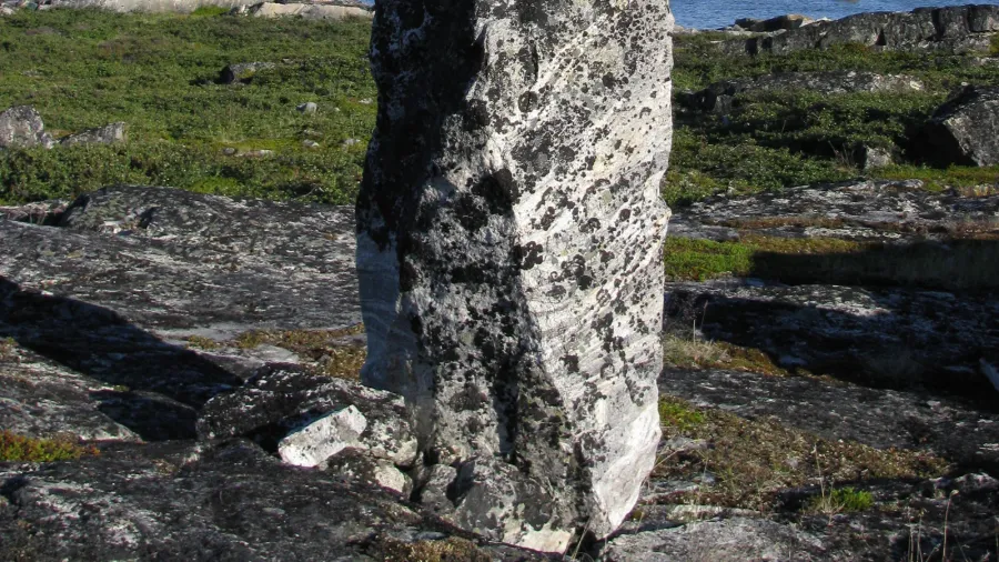
Sixteen miles west of the Inuit village of Kangirsuk, where the cold current of the Arnaud River cuts across the treeless rock of northern Quebec, three stacked boulders rise against the subarctic sky. Balanced atop a windswept ridge above the northern riverbank, the monument forms a stark geometric T-shape that measures 3.3 meters (10.8 feet) in height and weighs roughly 1,800 kilograms (4,000 pounds). For centuries, travelers paddling along the waterway formerly charted as the Payne River passed below the ridge without suspecting that this solitary stone column would ignite one of the fiercest archaeological debates in twentieth-century Canada.
When Canadian archaeologist Thomas E. Lee reached the site during an anthropological expedition to the Ungava Peninsula in 1964, he looked at the three-piece megalith and saw Europe in the Arctic. Convinced that indigenous builders would not assemble such a heavy cross-shaped tower, Lee named the structure the Hammer of Thor and declared it physical proof that Norse explorers had colonized the western shore of Ungava Bay a thousand years earlier. Subsequent research by Arctic archaeologists dismantled that claim, tracing the monument to the older, deeply rooted stone-building traditions of the Dorset culture and Inuit navigators who engineered landmarks across Nunavik long before European ships entered Hudson Strait.
 Figure 1: Scale diagram and silhouette of the Hammer of Thor monument along the Arnaud River in the Ungava Peninsula, Quebec, illustrating its three stacked stone components rising 3.3 meters above the tundra (Source: Wikimedia Commons).
Anatomy of a two-ton stone tower on the Arnaud River
The engineering of the Hammer of Thor relies entirely on gravity, friction, and raw mass. Located at 60°00′14″N, 70°26′10″W, approximately 24 kilometers (15 miles) inland from Payne Bay and 25 kilometers (16 miles) upriver from Kangirsuk, the structure consists of three unworked Precambrian rock blocks stacked vertically without mortar. The base is an upright stone shaft standing 2.44 meters (8 feet) high. Balanced horizontally across its narrow top sits a massive stone crosspiece measuring 1.37 meters (4.5 feet) in length, crowned by a third flat capstone rising another 35.56 centimeters (14 inches).
Hoisting a multi-hundred-kilogram crossbar more than two meters into the air across loose subarctic shield rock required coordinated labor, leverage, and an intimate knowledge of stone balance. In an environment where winter freeze-thaw cycles, fierce tundra gales, and shifting permafrost routinely topple poorly anchored cairns, the three stones have remained locked in equilibrium for generations. The sheer weight of the 35-centimeter capstone presses downward on the horizontal crossbeam, pinning it against the vertical pillar and stabilizing the center of gravity against lateral wind loads blowing off Ungava Bay.
Paradoxically, despite its 3.3-meter height, the monument is almost impossible to spot directly from the water of the Arnaud River. Positioned behind the crest of the northern river terrace, the stone column remains hidden to the naked eye from boats passing along the main channel or walkers approaching the lower beach. Only when a traveler climbs the rocky slope at a specific angle does the T-shaped profile suddenly break the horizon line, standing sharp against the pale northern sky.
 Figure 2: The rugged Precambrian rock terrain of Rock Valley near Kangirsuk in Nunavik, Quebec, supplying the dense glacial boulders and stone slabs used by Arctic builders along the Arnaud River corridor (Photo: Steven Roberge / Wikimedia Commons, CC BY 2.0).
The 1964 Ungava expedition and Thomas Lee’s Norse theory
Why did a traditional Arctic stone cairn acquire the name of a Norse thunder god? The answer lies in the intellectual climate of the early 1960s, right after Norwegian explorers excavated verified eleventh-century Viking turf walls at L’Anse aux Meadows on the northern tip of Newfoundland. Across North America, researchers began scanning the eastern Canadian coastline for further traces of Norse exploration, eager to prove that medieval Greenlanders had pushed deep into the Hudson Strait and Ungava Bay.
Thomas E. Lee, an archaeologist conducting fieldwork in northern Quebec, became the most vocal proponent of a vast Norse presence in Nunavik. Arriving along the Arnaud River in 1964, Lee interviewed local Inuit residents in the Kangirsuk area, who informed him that the standing pillar had existed for as long as oral memory recorded and predated the arrival of their own immediate ancestors. Rather than attributing the monument to earlier Paleo-Eskimo populations such as the Dorset people, whom Inuit oral histories remember as the Tuniit, Lee leaped to a trans-Atlantic conclusion.
To Lee, the vertical pillar and horizontal crossbar resembled a stylized Christian cross or the pagan Mjölnir hammer amulet worn by Scandinavian seafarers during the late Viking Age. Between 1964 and the early 1970s, Lee excavated coastal sites around Ungava Bay, arguing that long stone alignments, stone shelters, and the Arnaud River pillar belonged to a forgotten Norse colony. Canadian author Farley Mowat popularized Lee’s claims in his speculative books on northern exploration, cementing the Hammer of Thor moniker in popular atlases of Canadian curiosities.
 Figure 3: NASA MODIS satellite view of Ungava Bay and the eastern Ungava Peninsula during the June thaw, showing the coastal waters and river estuaries navigated by Dorset, Thule, and Inuit hunters for millennia (Source: NASA GSFC / Wikimedia Commons, Public Domain).
The inuksuk tradition and the Dorset engineering reality
When modern Arctic archaeologists re-examined Lee’s sites across the Ungava Peninsula, the Viking hypothesis collapsed under empirical scrutiny. Excavations demonstrated that the stone foundations along the Ungava coast were classic Dorset longhouses, built by Paleo-Eskimo communities who inhabited the eastern Canadian Arctic between roughly 500 BCE and 1300 CE. Zero Norse metal artifacts, runic inscriptions, soapstone spindle whorls, or European ship rivets have ever been recovered from the Arnaud River valley.
Instead, the Hammer of Thor fits squarely within the ancient Arctic tradition of the inuksuk, the stone landmarks erected by Dorset, Thule, and Inuit peoples from Alaska to Greenland. Across the treeless expanses of Nunavik, where winter blizzards erase horizon lines and snow blankets every natural contour for eight months of the year, stone architecture functioned as essential infrastructure for survival. Builders assembled stacked boulders in distinct configurations to mark safe river crossings, indicate productive fishing rapids, signal food caches buried beneath gravel, and channel migrating caribou herds toward waiting hunters.
Within Inuit oral tradition, stories of the Tuniit consistently emphasize their extraordinary physical strength and their habit of moving colossal boulders that single hunters could scarcely budge. The T-shaped configuration along the Arnaud River is a known structural variant within the broader grammar of northern stone cairns, designed to stand high above winter snowdrifts. The statement by Kangirsuk elders in 1964 that the monument predated their arrival was an accurate historical transmission: their Thule ancestors had migrated into the Ungava region centuries after Dorset builders had already erected stone markers along the river.
 Figure 4: The northern village of Kangirsuk on the lower Arnaud River in Nunavik, Quebec, located 25 kilometers east of the Hammer of Thor monument near the western shore of Ungava Bay (Photo: JA Béland / Wikimedia Commons, CC BY-SA 4.0).
Why the Viking myth persisted in the Canadian Arctic
The strange afterlife of the Hammer of Thor illustrates how colonial assumptions distorted twentieth-century archaeology across North America. For generations, when European and Euro-Canadian surveyors encountered monumental stonework, including earthen mounds in the Ohio Valley, stone chambers in New England, or two-ton balanced pillars in northern Quebec, many instinctively searched for Old World architects. Assigning the Arnaud River inuksuk to tenth-century Vikings stripped indigenous Arctic societies of their engineering credit, reframing an indigenous navigational monument as a European relic.
In reality, the Ungava Peninsula required far more specialized adaptation than any brief Norse foraging voyage could sustain. Spanning more than 250,000 square kilometers of tundra, crater lakes, and tidal estuaries where Ungava Bay experiences some of the highest tidal ranges on Earth, the region demanded permanent mastery of stone, ice, and seasonal animal migrations. The builders who levered the 1,800-kilogram blocks of the Hammer of Thor into position did so because their lives depended on reading and marking the river corridor across generations.
Sixty years after Thomas Lee christened the pillar after a Scandinavian deity, the monument still watches over the northern bank of the Arnaud River at the 60th parallel. Unaltered by mortar, untouched by road networks, and accessible only by boat, snowmobile, or foot across the Nunavik tundra, the three balanced boulders remain what they were from the day their builders wedged the capstone into place: a masterwork of indigenous Arctic stone engineering that outlasted both the people who raised it and the modern myths projected onto its silhouette.