· Castles & Palaces · 4 min read ·
The Flanders Water Fortress That Dictated Six Wars With a Single Lock
In the Flanders lowlands, a single canal junction dictated six continental wars, leaving ditch-jumpers who drank tea from Imperial Chinese porcelain.
When autumn rain turns the Belgian polders into liquid clay, the water at the junction of the Ghent-Bruges and Plassendale-Nieuwpoort canals runs flat and gray. Three centuries ago, an armed sentry standing here controlled the naval arteries of northwest Europe. Turn the heavy iron wheels of the lock gates one way, and military supply barges glided unhindered between the North Sea and the fortified cities of Bruges and Ghent. Turn them the other way, and millions of gallons of seawater flooded the low-lying countryside, transforming farmland into an impassable swamp.
This strategic choke point in modern-day Oudenburg was the site of Fort Plassendale. Unlike the towering stone citadels of the Rhineland, this was an aquatic bastion engineered from earthen dikes, sluices, and water-filled moats. Between 1581 and 1781, it stood at the epicenter of European geopolitical conflict, directly embroiled in six separate continental wars without ever possessing a permanent garrison of aristocratic cavalry.
The Cartographer’s Fortress
The origin of Fort Plassendale was born of political fracture. Following the 1581 Act of Abjuration, the Dutch declaration of independence from Spanish King Philip II, the Franc of Bruges found its access to the sea severed by insurgent forces. The regional council commissioned renowned cartographer and painter Pieter Pourbus to survey the flat expanse between Bruges and the coast.
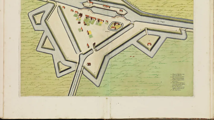
Pourbus understood what classical siege engineers routinely overlooked: in the Low Countries, water level was deadlier than cannon fire. His blueprints laid out an engineered fortress straddling the canal intersection. Earthen ramparts absorbed iron cannonballs far more effectively than rigid masonry, while an intricate network of sluice gates turned the surrounding polder drainage channels into defensive weapons.
 Figure 1: Frederik de Wit’s 1698 plan of Fort Plassendale illustrates the engineered star ramparts guarding the canal intersection.
Control of this watery hub determined the tempo of six distinct conflicts across two centuries: the Eighty Years’ War, the War of Devolution, the Franco-Dutch War, the Nine Years’ War, the War of Spanish Succession, and the War of Austrian Succession. When French armies under Louis XIV pushed toward the North Sea, or when the Duke of Marlborough maneuvered Allied divisions across Flanders, Plassendale’s locks served as the decisive logistical lever. Cut the barges here, and siege artillery ran out of gunpowder within days.
Porcelain in the Polders
Behind the militarized dikes lived a civilian ecosystem. Because armed traffic and merchant vessels were forced to halt for inspections and toll payments, the fortress grew into a crowded inland checkpoint. Innkeepers brewed dark Flemish ales, lock keepers regulated the daily flow of timber and grain, and specialized contractors managed dike maintenance.
Among the most vital residents were the ketsers, canal laborers who harnessed themselves to heavy tow ropes and dragged loaded wooden barges against the current with raw muscle power.
 Figure 2: The Plassendale lock complex preserves the centuries-old waterway junction where towpath laborers pulled freight barges.
Examinations of 18th-century probate records and estate inventories in Oudenburg revealed a startling material contradiction inside the modest homes of these towpath workers. Alongside serrated iron eel forks forged for spearing supper in muddy ditches, and ash-wood vaulting poles used to leap across flooded drainage trenches, estates consistently listed pieces of delicate, hand-painted Chinese export porcelain.
This unexpected luxury stemmed from Plassendale’s proximity to Ostend. In the early 1700s, the newly chartered Ostend Company (Oostendse Compagnie) sent trading flotillas to Canton and Bengal, returning with precious tea, silk, and porcelain. As goods funneled through the inland canal checkpoints, exotic tableware found its way onto the rough-hewn oak tables of illiterate barge pullers and dike builders.
 Figure 3: The historic cargo vessel Tordino rests near the surviving Spanish Toll House along the quiet canal embankment.
Dismantled by Free Trade
Fort Plassendale survived two centuries of bombardment, siege maneuvers, and shifting imperial boundaries. Ultimately, global commerce achieved what opposing artillery could not: the complete obsolescence of Plassendale’s earthen defenses.
In 1781, Holy Roman Emperor Joseph II declared the nearby port of Ostend a free-trade zone to capitalize on international maritime traffic during the American Revolutionary War. Commercial shipping exploded overnight. The heavy drawbridges, narrow rampart sluices, and armed inspection tollhouses at Plassendale suddenly became an intolerable bottleneck for high-volume commercial convoys.
Within years, the Austrian administration ordered the fortress dismantled. Workers leveled the earthen star bastions and filled the secondary moats with gravel to widen the towpaths.
Today, the only surviving remnant is the Spanish Toll House (Spaans Tolhuis), which has been undergoing careful architectural restoration since 2018. Where thousands of foreign soldiers once guarded the keys to Flanders, cyclists now glide along the tranquil canal towpaths, tracing the phantom lines of an earthen citadel that held the balance of European empires in its sluice gates.